If you are a subscription customer using Revit, then listen up. Autodesk has finally posted their Google Earth extension that you can download to add your project to Google Earth or bring a Google Earth image into your project. Simply log into your subscription site and look for the Revit Globe - Link. You will find it on the "Autodesk Building Solutions Product Modules, Add-Ons, and Enhancement" page.

 If you want to publish your 3D model into Google Earth, you will need to switch to a 3D view in Revit and use the Publish to Google Earth tool. This will add a Temporary Place to your list inside of Google Earth. You can then zoom and orbit to see how your building fits within its context.
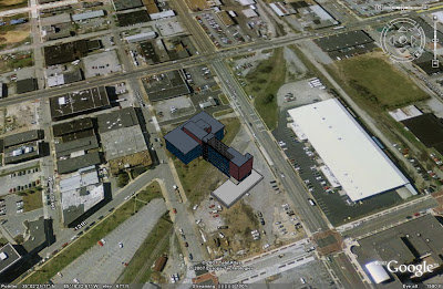
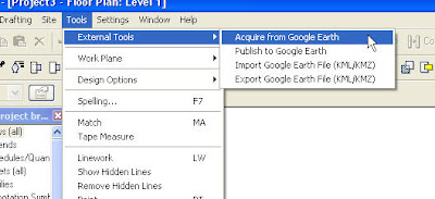
Once you have installed this, it will load some new commands to your Tools pulldown menu.
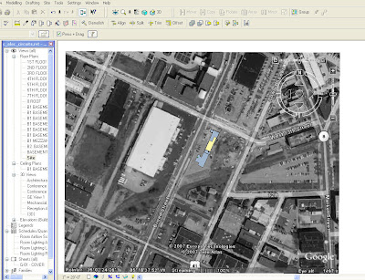
You must have Google Earth downloaded, installed, and running to use these tools. If you want to bring in an image from Google Earth, simple navigate to your site in Google Earth, then switch to Revit and use the Acquire from Google Earth tool. It works great for creating a site plan with the surrounding terrain.
If you want to publish your 3D model into Google Earth, you will need to switch to a 3D view in Revit and use the Publish to Google Earth tool. This will add a Temporary Place to your list inside of Google Earth. You can then zoom and orbit to see how your building fits within its context. This is just a quick example of how you can begin to move your model to a site.
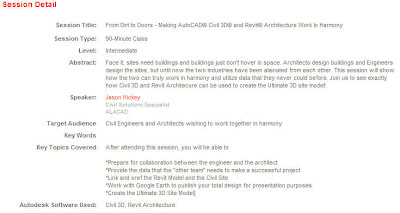
I will take this opportunity to advertise for one of the Autodesk University classes that I will be assisting with. It is not being advertised very well to the architectural community because it is listed in the Civil track. I am teaching "From Dirt to Doors" with my in-house Civil guru, Jason Hickey. Check it out the description below and sign up for it.
I will take this opportunity to advertise for one of the Autodesk University classes that I will be assisting with. It is not being advertised very well to the architectural community because it is listed in the Civil track. I am teaching "From Dirt to Doors" with my in-house Civil guru, Jason Hickey. Check it out the description below and sign up for it.
11 comments:
Has Google Earth changed their licensing so that the free version can be used for commercial purposes? The licensing model for GE pro, which licenses the application to both the machine and a specific username, is not conducive to enterprise use, and the last time I read the GE free version EULA, it was innapropriate to any sort of professional usage.
Can you import 3d terrain from Google earth to use with Revit or is it just a flat picture?
It will import a flat image only.
Er, maybe I am retarded but when I log in to the subscription center I don't even have a "Autodesk Building Solutions Product Modules, Add-Ons, and Enhancement" page! Does anyone know if there is a download mirror or can someone post this somewhere?
Here is the link. I think you will have to log into you subscription site first. Let me know if the link works.
http://pointa.autodesk.com/getPage?action=landing&id=bsd
Nope doesn't work...
Here is a link for the beta
http://labs.autodesk.com/utilities/google_earth_extension_beta/
Thanks for the link. Question though, do you know how to make the graphic show up in the site plan view? The import tool will not allow me to import on the siteplan layer, nor will it allow me to see it in siteplan layer after importing on the ground floor.
That extension doesn't work for simple AutoCAD. It needs Civil or Map 3D to bring images in place.
I would recommend you to use a tool I found named Plex.Earth.
I select my coordinate system (even in simple AutoCAD) and create a "mosaic" with color images from Google Earth in order to cover large areas with better resolution. Or you can draw a rectangle in AutoCAD and it automatically zooms Google Earth in the area.
It saved me a lot of time I used to spend for things I should nοt care about.
That's the link to download:
http://www.plexscape.com
thank you...
Post a Comment